Full article · 7 min read
Roman roads: milestones and the birth of the mile
On Roman roads, distance was not an abstract idea. It stood beside the traveler in stone.
Across the vast Roman road network, milestones turned journeys into something measurable, recordable, and surprisingly modern. They marked out the road mile by mile, told travelers how far they had come, and often announced who had built or repaired the route. In a world connected by hundreds of thousands of kilometres of roads, these markers helped make movement across the Roman state more organized and more precise.
Why milestones mattered
Roman roads were essential to the maintenance and growth of the Roman state. They moved armies, officials, civilians, messages, and trade goods across an enormous territory. At the height of Rome’s development, 29 great military highways radiated from the capital, and 372 great roads linked the empire’s 113 provinces. Altogether, the network exceeded 400,000 kilometres, with more than 80,500 kilometres stone-paved.
A system on that scale needed more than road surfaces and bridges. It also needed a way to measure distance consistently.
That is where the milestone, or miliarium, came in. 
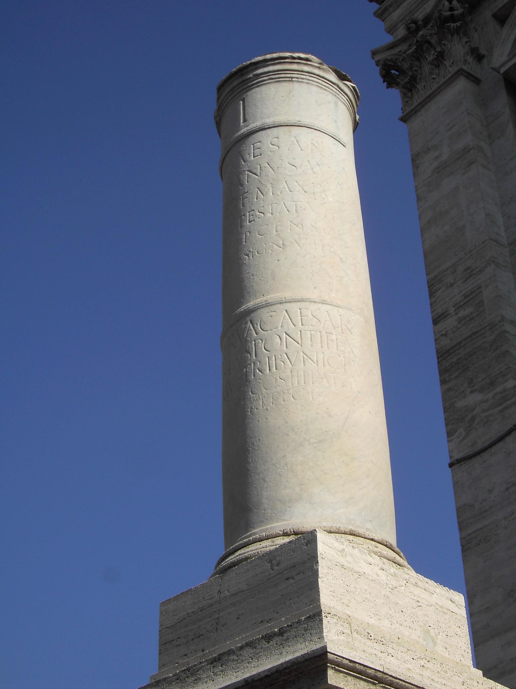
Milestones divided roads into numbered miles, making it possible to know exactly where you were on a route. They were practical tools for travelers, officials, and administrators, and they also became valuable records of public works.
The Roman mile: where the modern word comes from
The modern word mile comes from the Latin milia passuum, meaning “one thousand paces.” In the Roman system, each pace counted as five Roman feet, giving a Roman mile a total length of 1,476 metres.
That detail matters because it shows how closely Roman distance measurement was tied to the human body and to travel on foot. A pace is easy to imagine: a repeated step length made formal and standardized. By converting that everyday motion into an official unit, the Romans created a practical way to map roads, calculate journeys, and organize administration.
The result was a distance marker system that feels remarkably familiar. Even today, road travel depends on regular signs telling us how far we are from a destination. Roman milestones performed much the same role.
What a Roman milestone looked like
A typical miliarium was not a small roadside post. It was a substantial monument.
According to surviving descriptions, a milestone was a circular column mounted on a solid rectangular base. It was set more than 2 feet, or 0.61 metres, into the ground for stability. Above ground, it stood 5 feet, or 1.5 metres, tall, with a diameter of 20 inches, or 51 centimetres. It weighed more than 2 tons.
That physical heft tells you something important about Roman road culture. These were not temporary signs or painted boards. They were meant to last, to resist weather and time, and to make state authority visible on the landscape.
At the base, the stone carried the number of the mile for that point on the road. At eye height, an inscription gave the distance to the Roman Forum and often included information about the officials who made or repaired the road and when the work was done.
So a milestone was both a measuring device and a public record. It told you where you were, but it also told you something about power, responsibility, and infrastructure.
More than road signs: records carved in stone
Because milestones often named officials connected to a road’s construction or repair, they became important historical evidence. Their inscriptions preserve details about public works that might otherwise have vanished.
This habit fits Roman road culture more broadly. Roads were often named after the censor who ordered their construction or reconstruction, such as the Via Appia, Via Cassia, or Via Flaminia. Public roads were closely connected to civic prestige, and major figures sought to associate themselves with road building and maintenance. Gaius Gracchus, for example, paved or gravelled many public roads and provided them with milestones and mounting-blocks for riders.
That means a milestone was never just about distance. It could also be a kind of official signature in stone.
The Golden Milestone: the symbolic center of the road world
As the Romans expanded their road network, they also showed a strong preference for standardization. Augustus, after becoming permanent commissioner of roads in 20 BC, set up the miliarium aureum, or “Golden Milestone,” near the Temple of Saturn in Rome.
This monument had a special status. All roads were considered to begin from it.
That does not mean every road physically started at that exact spot. The point was symbolic and administrative. The Golden Milestone represented Rome as the central reference point of the entire network. Distances to the major cities of the empire were listed on this gilded bronze monument, turning it into a geographic statement about Rome’s place in the world.
It was a powerful idea: a vast imperial road system, stretching across continents, conceptually anchored to a single marker in the capital.
The “navel of Rome”
The Golden Milestone later acquired another striking name. Constantine called it the umbilicus Romae, meaning the “navel of Rome.”
The word umbilicus literally means “navel,” but in this context it means a symbolic center point, the place from which the surrounding world is conceptually ordered. It is the same idea behind calling something the heart or hub of a system.
Constantine also built a similar, though more complex, monument in Constantinople known as the Milion. This shows how central milestones had become not just to measurement, but to imperial identity. A great capital was expected to have a central marker from which distances and connections radiated.
How milestones helped people think about history
Roman milestones did more than support travel. They also shaped how people described events.
Because distances and locations could be known and recorded so exactly, historians began to refer to the milestone at which an event occurred. That is a remarkable development. It means the road system gave history a more precise geography. Events could be pinned to a specific point along a route, not just vaguely placed near a town or region.
This precision was possible because Roman roads themselves were carefully organized. Surveyors laid them out with attention to straightness, and many roads were built to resist rain, freezing, and flooding. The entire network relied on measurement, planning, and durable engineering. Milestones were a visible extension of that mindset.
Milestones inside a much larger travel system
The milestone made most sense as part of a complete travel infrastructure.
Travelers on Roman roads could consult itineraries, which were route lists showing towns and distances along a road. Some were simple practical lists; others evolved into more schematic route planners. The Roman government even commissioned master road itineraries. Milestones on the ground and itineraries in written form supported each other. One gave you the physical marker on the roadside; the other helped you plan the larger journey.
Way stations also fit into this measured world. Mansiones, official stopping places, were usually about 25 to 30 kilometres apart. Mutationes, changing stations for animals and vehicles, were generally placed every 20 to 30 kilometres. Distances mattered for everything: rest, relays, official travel, and communication.
Under the empire, the cursus publicus, founded by Augustus, carried official mail across the Roman road system by relay. In a network like that, exact distance markers were not decorative. They were useful administrative tools.
Why the mile endured
The Roman mile survived not because it was just a unit, but because it belonged to an entire culture of organized movement. Roman roads connected cities, military bases, rivers, and seas. They were financed, maintained, inspected, repaired, and documented by a range of officials and magistrates. Milestones fit naturally into that world because they made the network legible.
They transformed roads from mere paths into measured lines through space.
And while many Roman roads still survive in their courses, the idea behind the milestone may be even more enduring. The very word mile still carries the memory of milia passuum. Every time distance is marked, counted, and posted for the traveler, it echoes a Roman habit of turning movement into something exact.
A stone that spoke
The most striking thing about Roman milestones may be how much information they compressed into a single object. A traveler could read distance, location, authority, and direction from one carved stone.
That makes the milestone a perfect symbol of Roman roads themselves: practical, durable, and designed to hold a huge state together.
A road told you where to go. A milestone told you exactly where you stood.
Sources
Based on information from Roman roads.
More like this
Measure your curiosity one swipe at a time—download DeepSwipe and hit the next milestone in your knowledge journey.


