Oceania is one of the most unusual geographic regions on Earth because its pieces are not joined mainly by land. They are joined by ocean. That idea helps explain why Oceania can feel simple on a classroom map but become surprisingly complicated the moment someone asks a basic question: which islands actually count?
At its broadest, Oceania includes Australasia, Melanesia, Micronesia, and Polynesia. In many descriptions, it is treated as a continent or one of the world’s major continental divisions. Yet its borders have long been debated. Some definitions focus on culture, some on politics, some on geology, and some on where people first settled. That is why different maps can show very different versions of Oceania.
Watch the story on DeepSwipe
Why Oceania is different
The very name points to what makes the region special. The term comes from a word for ocean, and that is fitting: unlike other continental groupings, the sea is what connects Oceania’s parts together. Instead of one continuous block of land, the region is made up of thousands of islands spread across an enormous area.
Oceania spans both the Eastern and Western hemispheres and sits at the center of the water hemisphere. Its total land area is about 9,000,000 square kilometres, with a population of around 46.3 million as of 2024. By land area, it is the smallest continent, and by population it is second least populated after Antarctica.
That enormous spread helps explain why defining Oceania has never been easy. A map can group islands together, but geography alone does not settle every argument. Political boundaries, geology, cultural history, and even older scholarly traditions all shape how people draw the region.

The four familiar subregions
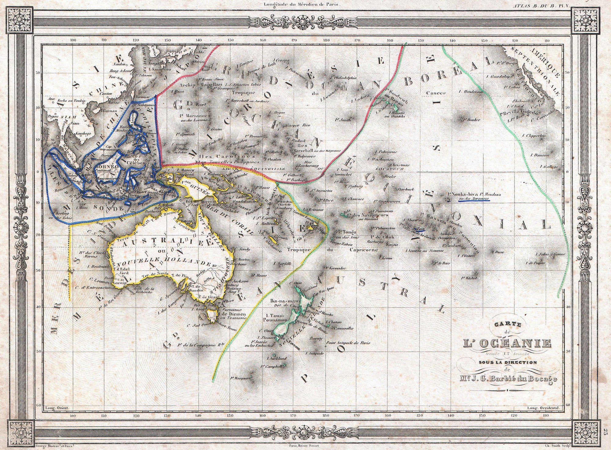
A common modern framework divides Oceania into four subregions: Australasia, Melanesia, Micronesia, and Polynesia.
Australasia includes Australia, New Zealand, and neighbouring islands in the Pacific. Melanesia lies to the southwest and includes New Guinea, the Bismarck Archipelago, the Solomon Islands, Vanuatu, Fiji, and New Caledonia. Micronesia, north of the equator and west of the International Date Line, includes groups such as the Mariana Islands, Caroline Islands, Marshall Islands, and islands of Kiribati. Polynesia stretches across a vast area from Hawaii in the north to New Zealand in the south and includes island groups such as Samoa, Tonga, the Cook Islands, the Society Islands, the Marquesas, the Tuamotus, and Easter Island.
These names are still widely used in science, popular culture, and general usage. They give people a practical way to talk about the region, even though they do not settle every boundary dispute.
Why the borders are so disputed
The edges of Oceania are some of the most debated in world geography. Depending on the definition, islands at the outer limits may or may not be included. Among the places often discussed are the Bonin Islands, Hawaii, Clipperton Island, Easter Island, and Macquarie Island.
The disagreement exists for a few different reasons.
First, some definitions are geographical. These ask whether islands belong to the Pacific island world as a whole.
Second, some are political. These are used by international organizations for statistics, diplomacy, or sporting bodies.
Third, some are geological. These ask whether an island is oceanic in origin or instead part of a continental shelf or continental fragment.
Fourth, some are cultural or historical. These look at whether populations share connections with the peoples of the wider Pacific.
Because these approaches do not always point in the same direction, maps of Oceania can look very different from one another.
The United Nations version of Oceania
One of the most influential modern definitions comes from the United Nations. Since 1947, the UN has used a geopolitical definition built around four subregions: Australasia, Melanesia, Micronesia, and Polynesia. This version is also used in statistical reports, by the International Olympic Committee, and by many atlases.
Under this system, Oceania includes places such as Australia, New Zealand, Papua New Guinea, Fiji, Samoa, Tonga, the Solomon Islands, Vanuatu, Palau, the Marshall Islands, Kiribati, French Polynesia, Guam, and many others.
But this definition also excludes several places that many people might assume belong to Oceania. Hawaii is left out. So are the Bonin Islands, Clipperton Island, the Juan Fernández Islands, and Easter Island. It also excludes Indonesia, Japan, the Philippines, Singapore, and Taiwan, even though all of them are located within the Pacific or its marginal seas.
This shows how a political definition can differ sharply from a broader geographic or cultural one.
Why Hawaii and Easter Island are so controversial
Few places reveal the problem better than Hawaii and Easter Island. Both are strongly associated with Polynesia in many cultural or historical discussions. Yet they are not always included in political definitions.
Hawaii has often been treated as part of Oceania in broader interpretations, but it is excluded from the UN system. Easter Island is another classic border case. Some definitions include it because of its Polynesian and biogeographic affinities, while others exclude it because it is politically part of Chile.
In other words, a map that emphasizes political administration may leave them out, while a map that emphasizes Pacific cultures or island geography may bring them back in.
Near Oceania and Remote Oceania
To move beyond older regional labels, anthropologists Roger Green and Andrew Pawley proposed the terms Near Oceania and Remote Oceania in 1973.
Near Oceania includes New Guinea, the Bismarck Archipelago, and the Solomon Islands except the Santa Cruz Islands. Remote Oceania refers to the islands farther out into the Pacific that were settled later.
These terms were meant to replace the older categories of Melanesia, Micronesia, and Polynesia, which had been shaped in the 19th century and were often tied to racial thinking. Since the early 1990s, many scholars have preferred the newer terms, especially when discussing human settlement and prehistory.
Even so, the older labels remain deeply rooted. They are still common in science, in schools, in atlases, and in everyday speech.
The deeper history behind the map
Part of the reason these definitions matter is that Oceania was not settled all at once. The first settlers of Australia, New Guinea, and the large islands just to the east arrived more than 60,000 years ago. Much later, Austronesian-speaking peoples spread outward into more distant island regions.
That difference in settlement history helps explain why some scholars prefer Near and Remote Oceania. The terms reflect different waves of human migration and the fact that islands closer to New Guinea were inhabited much earlier than many islands farther east.
This history also helps explain why cultural boundaries do not always line up neatly with political ones. The Pacific is a region where seafaring, migration, and island networks shaped human life over very long periods.
A region held together by the sea
Although its boundaries are debated, the basic idea of Oceania remains powerful. It is a region of islands linked across the Pacific by water rather than by continuous land. That is true whether someone uses a narrow political definition or a wider geographic one.
This marine connection is not just poetic. It affects how the region is studied and understood. Its islands are spread from New Guinea in the west to islands such as Easter Island and Sala y Gómez in the east under a four-subregion model, and from the Bonin Islands in the north to Macquarie Island in the south. Many of these islands are volcanic, some are coral formations, and others are continental fragments. What they share is their relationship to the ocean.
That is why Oceania so often challenges the tidy logic of textbooks. It is not simply a piece of land with obvious edges. It is a vast island world whose identity depends on how you think about geography itself.
So what counts as Oceania?
The honest answer is: it depends on the map, and on the purpose of the map.
If the goal is international statistics, the UN definition is likely to be used. If the goal is cultural or historical discussion, Hawaii or Easter Island may be included. If the goal is archaeology or migration history, Near Oceania and Remote Oceania may be more useful than the traditional four-part model.
That does not make Oceania confusing so much as revealing. It shows that regions are not only natural facts; they are also ideas shaped by history, politics, science, and culture.
Oceania is a continent linked by water, but exactly which shores belong to it has never had just one answer.